
Flood Warnings
OVERVIEW
- A few flood warnings continue this evening, but river levels are receding and no new flooding is anticipated tonight.
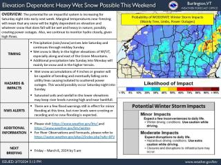
- The potential for an impactful and long duration system is increasing for Saturday night into early next week, with a heavy wet snowfall and minor flooding possible.
- The first part arrives late Saturday into Saturday night with a mix of snow and rain, with the greatest probability of 4 inches or more of snowfall occurring across the higher terrain of the northern Adirondacks and along and east of the Green Mountain Spine.
- Given marginal temperatures this will be a highly elevational dependent snowfall.
- The heavy wet snow could cause isolated to scattered power outages on Saturday night into Sunday.
- Second part of the system arrives late Sunday into early next week with a prolonged upslope accumulating snowfall likely. The exact snowfall amounts and duration will become clearer over the next couple of days.
- Given high river flows from recent rainfall and snowmelt and additional precipitation this weekend, minor flooding is possible.
Please see the attached briefing for more details.
https://newengland511.org/region/Vermont
Flood | Avoid Impacted Areas (Avoid Floodwater-Dangers Hidden; "Turn Around, Don't Drown!") (fema.gov)
DISCLAIMERS & CONTACT INFO
A reminder: These e-mails are to help prepare you for upcoming weather events and to increase your situational awareness, but are not the source for weather warnings.
Closely monitor future forecasts via www.weather.gov/btv (or NWS Albany at www.weather.gov/aly for Bennington and Windham Counties).
If you have any questions, please feel free to contact us 24/7 via:
1. Telephone: 802-863-4279 or 802-658-0150
2. Email: nwsbtv.info@noaa.gov
3. NWSChat for eligible & registered users at https://nwschat.enterprise.slack.com/
Thanks
Brooke